Swat, Switzerland of Pakistan
·


Most Beautiful and Romantic Place Which is Also Called Peace Of Heaven
swat is the most beautiful place of Pakistan which is also called mini Switzerland of Pakistan. People from all over the world come there to see the gift of Almighty God.
It is situated in the province of N.W.F.P and the Capital is Peshawar.
located 160 kilometers from Islamabad.It is the upper valley of the Swat River, which rises in the Hindu khusrange. The capital of Swat is Saidu Sharif but the main town in the Swat valley is Mingora.
With high mountains, green meadows, and clear lakes, it is a place of great natural beauty that used to be popular with tourists as "theSwitzerland of Pakistan.


History
The names found in ancient sources for Swat are Udyana and Suvastu because of the scenic beauty of the valley and the name of the river respectively. Swat has been inhabited for over two thousand years. The first inhabitants were settled in well-planned towns. In 327 BC,Alexander the Great fought his way to Udegram and Barikot and stormed their battlements. In Greek accounts these towns have been identified as Ora and Bazira. Around the 2nd century BC, the area was occupied by Buddhists, who were attracted by the peace and serenity of the land. There are many remains that testify to their skills as sculptors and architects. In the beginning of the 11th century AD, Mahmud of Ghazni advanced through Dir and invaded Swat, defeating Gira, the local ruler, near Udegram. Later the land was taken over by theDilazak, who in turn were ousted by the Yusufzais. The originator of the present family of Swat was the Muslim saint Abdul Ghafoor, a Safi Momand of Hazara district, from where he went to Buner territory. He was a pious man and the people respected him so greatly that they called him AKHUND SAHIB.[2]
It was the mid-19th century when Muslim tribes were fighting against each other for the possession of Swat Valley. On the intervention of the honourable Akhund Sahib, the killing was stopped, and such was his influence that the chiefs of all tribes unanimously made him the ruler of the valley. Akhund Sahib administrated the valley according to Muslim laws. Peace and tranquility prevailed, and agriculture and trade flourished in the territory. Akhund Sahib had two sons by his wife, who belonged to Nikbi Khel.
After the death of Akhund Sahib, the tribal chiefs again started fighting and killing, which continued for years. Eventually the tribal chiefs agreed to give the control of the valley into the hands of the honourable Gul Shahzada Abdul Wadood, the son of Mian Gul Abdul Khaliq, son of Akhund Sahib. The wife of Mian Abdul Wadood was the daughter of Honorable Mirza Afzal-ul-Mulk, the ruler of Chitral. The British by trick put Chitral under the suzerainty of Kashmir. The Chitral ruler gave two horses every year to the Rajia of Kashmir, and the Raja provided Chitral with grain and sugar, etc. Swat thus went under protection of the British.
During the rule of Mian Gul Muhammad, Abdul Haq Jehanzeb, the son of Mian Abdul Wadood, the state acceded to Pakistan in 1947. The present prince, Muhammad Aurzngzeb Khan, son of Jahanzeb, married the daughter of Field Marshall Mohammad Ayub Khan in 1955. Thus by intermarriages with the other castes, the family became a branch of the imperial Gujjars. Jahznzeb started a Degree College at Saidu Sahrif, the capital of the State, and four High Schools at Mingora, Chakesar, Matta and Dagar. Fourteen middle schools, twenty-eight lower middle schools, and fifty-six primary schools were established. A girls high school and high class religious schools were established at Saidu Sharif. At all the schools, the poor students were granted scholarships. The state was an exemplary state during British rule. The Gujjars were very poor people in the Swat Valley, but nowadays they have diverted their attention towards education and are holding good posts in government services. They also have a firm stand in politics of Pakistan. The current Prince Aurangzeb Khan was also Governor ofBaluchistan.


Northern Areas of Pakistan
Northern Areas of Pakistan, spread over 72,496 sq. km are as fascinating as its southern region. Amidst towering snow-clad peaks with heights varying from 1,000 m to 8,000 meters, the regions of Gilgit, Hunza, Baltistan and Shangri-La. The cultural patterns of these regions are as interesting as its geography. The people with typical costumes, folk dances, music and sports like polo and buzkashi, provide the traveller an unforgettable experience.
Out of 14 over 8,000 meters high peaks on earth, 4 occupy an amphitheater at the head of Baltoro glacier in the Karakoram range in Northern Pakistan. These are; K-2 or Mount Godowin Austin (8,611 m, world's second highest), Gasherbrum-I (8,068 m),Broad Peak (8,047 m) and Gasherbrum-II (8,035 m).
There is yet another which is equally great, Nanga Parbat (8,126 m), located at the western most end of the Himalayas. In addition to these mountains, there are 68 peaks over 7,000 m and hundreds others of over 6,000 meters.
The Northern Pakistan has some of the longest glaciers outside Polar region; Siachen (72 km), Hispar (61 km), Biafo(60 km), Baltoro (60 km) and Batura (64 km).


Swat Valley
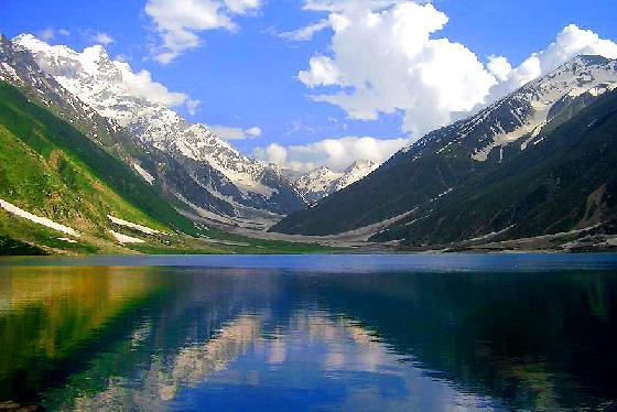
The Lush-green valley of Swat, with its rushing torrents, icy-cold lakes, fruit-laden orchards and flower-decked slopes is ideal for holiday-makers intent on relaxation. It has a rich historical past, too.
This is "Udayana" (the "Garden") of the ancient Hindu epics; "the land of enthralling beauty" where Alexander of Macedonia fought and won some of his major battles before crossing over to the plains of Pakistan. This is "the valley of the hanging chains" described by the famous Chinese pilgrim-chroniclers, Huain Tsang and Fa-Hian in the fifth and sixth centuries.
Swat was once the cradle of Buddhism of all its schools- Little Vehicle, Great Vehicle and the Esoteric sects where once 1,400 monasteries flourished. It was the home of the famous Gandhara School of Sculpture which was an expression of Graeco-Roman form in the local Buddhist tradition.
Swat was also the historical land where the Muslim conquerors, Mahmud of Ghazni, Babur and Akbar fought their battles preparatory to the conquest of the South Asia. The ruins of great Buddhist stupas, monasteries and statues are found all over Swat.
The valley of Swat sprawls over 10,360 sq. kms at an average elevation of 975 metres. The maximum temperature in July is 38 C and minimum (during January) is 1 C. The normal temperature is maximum 21 C and minimum 7 C. The tourist season is year-round.
Swat Valley is divided into 3 main areas, Saidu Sharif, Mingora and Kalam.


Saidu Sharif
Headquarters of Swat Valley, Saidu Sharif houses the Swat Museum which contains one of the finest collections of Gandhara art in the world.
Mingora
3 kms From Saidu Sharif, has yielded magnificent pieces of Buddhist sculpture and the ruins of great stupas. Other beauty spots worth visiting are Marghzar, 13kms from Saidu Sharif, famous for its "Sufed Mahal" or White Palace, the white marble palace of the former Wali (ruler) of Swat; Kabl, 16 kms from Saidu Sharif with its excellent golf course, Madyan, 55 kms from Saidu Sharif, Bahrain, Miandam and Kalam. Malam Jabba, at 2,636 metres above sea level and 45 kms north-east of Saidu Sharif is being developed as a ski-cum-summer resort.


Gilgit and Hunza Valleys
At an elevation of 1,454 metres lies the Gilgit Valley. The quaint little town of Gilgit has spectacular scenic beauty. The peak tourist season is from May to mid-October though the tourist season is round the year. The maximum temperature in May is 33 C and minimum 16 C. In September, Maximum 28 C and minimum 11C.
Places of Interests
10 kms from Gilgit town is a beautiful rock engraving of Buddha of 7th century A.D.at the mouth of the Kargah Nullah. A victory monument of Taj Mughal, built 700 years ago, is 30 kms. Jeep drive from Gilgit town.
The bridge over the fast flowing Gilgit river is the largest suspension bridge in Asia (182 metres long and 2 metres wide) permitting enough room for one jeep at a time to cross.


Activities in the area
The favourite sport in Gilgit is polo which local folks claim originated here. It's more rugged, free-style version than the sedate variety known in the plains. The polo tournament held from 1st November to 7th November is a festive occasion and draws a large number of visitors. The streams and lakes of Gilgit are full of trout.
Trekking and hiking in the rugged mountains and verdant valleys of Gilgit are allowed only in the "open zone" which extends up to 16 kms. short of the control line on the Kashmir border and up to 50 kms. short of the Afghan border.
Gilgit has direct route (about 600 km) from Islamabad/Rawalpindi by the Karakoram Highway. Rawalpindi to Gilgit via Swat is 750 kms and takes 20 hours by bus/van; Rawalpindi to Gilgit via Babusar Pass 592 kms 24 hours by jeep.
Hunza Valley
The visitors to Hunza are overwhelmed by the rugged charm, the fragrant breeze signing through graceful poplar trees and the velvet-like green carpet of wheat fields, set against the background of snow-covered mountains. Situated at an elevation of 2,438 metres, Hunza valley's tourist season is from May to October. The temperature in May is maximum 27 C and minimum 14 C. The October temperatures are: maximum 10 C and minimum 0 C.
Karimabad, the capital of Hunza, offers an awe-inspiring view of Rakaposhi Peak (7,788 metres). The snows of Rakaposhi glitter in the moonlight, producing an atmosphere at once ethereal and sublime. The fairy-tale like Castle of Baltit, above Karimabad, is a Hunza landmark built abut 600 years ago. Stilted on massive legs, its wooden bay windows look out over the valley. Hunza is ideal for mountaineering, trekking and hiking.


Chitral Valley and Kafiristan (Kalash Valley)
The Chitral Valley at an elevation of 1,128 metres, is favourite with mountaineers, anglers, hunters, hikers, naturalists and anthropologists. The 7,705 metres Trichmir, the highest peak of the Hindukush range, dominates this 322 kms long exotic valley.
Location
Chitral district has Afghanistan on its north, south and west. A narrow strip of Afghan territory, Wakhan, separates it from Tajikistan. The tourist season in Chitral is from June to September. The maximum temperature in June is 35 C and the minimum 19 C. In September the maximum is 24 C and minimum 8C.
Attractions
Kalash Valleys
One of the major attractions of Chitral are the Kalash valleys - the home of the Kafir-Kalash or "Wearers of the Black Robes", a primitive pagan tribe. Their ancestry is enveloped in mystery and is the subject of controversy. A legend says that five soldiers of the legions of Alexander of Macedonia settled in Chitral and are the progenitors of the Kafir-Kalash.
Over 3,000-strong Kafir-Kalash live in the valley of Birir, Bumburet and Rambur, south of Chitral. Bumburet, the largest and the most picturesque valley of the Kafir-Kalash , is 40 kms. from Chitral and is connected by a jeep-able road. Birir, 34 kms. away is accessible by a jeep-able road. Rambur is 32 kms from Chitral.
The Kalash women wear black gowns of coarse cloth in summer and hand-spun wool dyed in black in winter. Their picturesque headgear is made of woolen black material decked out with cowry shells, buttons and crowned with a large coloured feather.
The Kalash are fun loving people who love music and dancing particularly on occasion of their religious festival like Joshi Chilinjusht (14th & 15th May-spring), Phool (20th - 25th September) andChomas (18th to 21st December for a week). Polo in Chitral is as popular as in Gilgit. Polo matches are great attractions at festive occasions. A regular Polo tournament is held every year (First week of July) at Shandur Pass.


Kaghan and Naran Valleys
A holiday in the Kaghan Valley, the Himalayan hide-away, north-east of the Hazara district of Pakistan's North West Frontier Province, is an unforgettable experience. Its mountains, dales, lakes, water-falls, streams and glaciers are still in unbelievable pristine state, and unspoiled paradise. That is why it can be such a deeply satisfying experience to spend a few days in Kaghan.
Location
The Valley extends for 155 kms rising from an elevation of 2,134 metres to its highest point, the Babusar Pass, at 4,173 metres. Kaghan is at its best in the summer months (May to September). In May the temperature is: maximum 11 C and the minimum 3 C. From the middle of July up to the end of September, the road beyond Naran, snow-bound throughout the winter, is open right up to Babusar Pass.
The Kaghan Valley is accessible by road from Rawalpindi/Islamabad and Peshawar. You can drive in your own or a rented car, taxi, station-wagon or bus to Abbottabad which is 122 kms. from Rawalpindi and 217 kms. from Peshawar. Abbottabad is a charming town spread out over several low, refreshingly green hills.
Places to Visit
Balakot
From Abbottabad, you drive 72 kms to Balakot, the gateway to the Kaghan Valley. Balakot has the shrines of Syed Ahmed Shaheed and Ismail Shaheed Brelvi, the South Asia great freedom fighters.
For your drive to Kaghan, you switch over at Balakot to a jeep. Your first stop is 34 kms away at Shogran at 2,362 metres above sea level. At Kaghan, the little village that gives the valley its name-61 kms from Balakot.
Naran
At Naran, 23 kms from Kaghan you reach the half-way point. Naran also serves as the base for the whole valley. From here you can ride a jeep or horse or hike in excursions to several picturesque lakes, valleys and peaks.
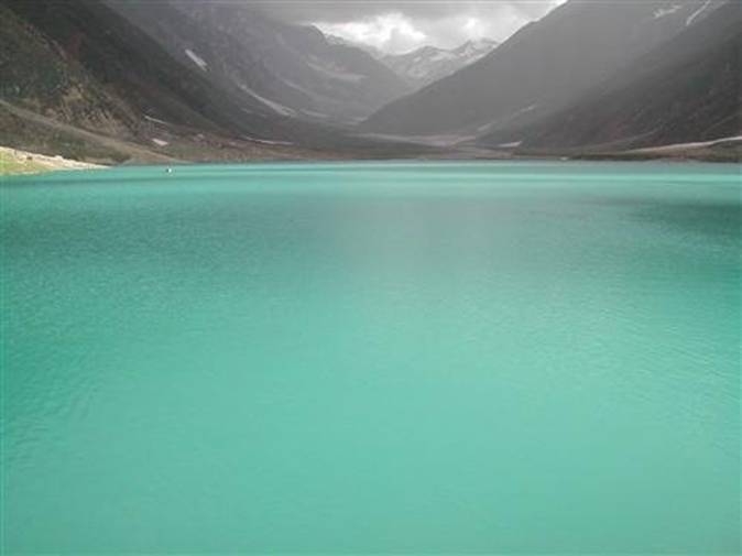
Lake Saiful Maluk
Lake Saiful Muluk has a touch of the unreal about it, nestling 3,200 metres high in the shadow of the Malika Parbat (Queen of the mountains) 5,291 metres high. You can go boating on the lake and hear the local legend about Prince Saiful Muluk who fell in love with a fairy. Further up are quaint woodland villages; Battakundi, Burawai, Besal Gittidas andLalazar.
Babusar Pass
The Kaghan Valley is blocked at the end by high mountains but a pass lets the jeep-able road snake over into theChilas Valley. This is the 4,173 metres high Babusar Pass which commands the whole Kaghan panorama as well as gives you, on a clear day, glimpses of the Nanga Parbat (The Naked Mountain) glistening at 8,126 metres.


Skardu and Deosai Plains (Baltistan)
Capital of Baltistan is perched 2,438 metres above sea level in the backdrop of the great peaks of the Karakoram mountain range. Baltistan is known as the "Tibet-e-Khurd" or Little Tibet since its life-style reflects that of the roof of the World and Land of Lamas.It borders on the Chinese province of Xinjiang and Indian-occupied Kashmir.
Places to Visit
Apart from its incomparable cluster of mountain peaks and glaciers Baltistan's five valleys - Shigar, Skardu, Khaplu, Rondu and Kharmangare noted for their luscious peaches, apricots, apples and pears.
Shigar valley, 32 kms by jeep from Skardu is the gateway to the mountain peaks of the Karakorams. Skardu has a historic Fort atop a ridge known as the Mindoq-Khar or Castle of Queen Mindoq and three lovely lakes. The two - Kachura Lake 29 kms andStapra Lake 8 kms from Sakrdu are ideal for fishing.
Deosai Plains
The Deosai Plains are 32 km south of Skardu. This plateau is the habitat of the greatly threatened Himalayan Brown Bear and many other wild animals. At an average elevation of 3500 metres, Deosai is now a National Park and protected area for wildlife.
The rolling grassland here supports no trees or shrubs and the area is snow covered for seven months of the year. Spring comes to Deosai in August when millions of wild flowers begin to bloom all over the lush green grassland. This is a time when Deosai looks like a paradise with a landscape full of wild flowers on green rolling hills and crystal clear water streams with snow covered peaks in the background.
An adventure jeep safari will take you right across the beautiful mountain ranges of the Himalayas and the Karakorams Travelling on KKH, you will enjoy the most spectacular scenery on earth.
Before reaching Deosai, you will also witness the magical views of Nanga Parbat (8126 m), the ninth highest peak of the world. At Deosai, you first stop will be at Sheosar Lake. This place offers beautiful views of south fact of Nanga Parbat and a panoramic view of Deosai Plains.
At Bara Pani, you can spend one day and visit the core of the National Park for Bear watching or you may enjoy fishing in the cold waters or Barwai Stream. From Deosai, you can travel back via Skardu and Gilgit to enjoy the most thrilling drive along the Indus River


Subscribe to:
Post Comments (Atom)


nice work dear keep it up ...
ReplyDeleteibrahim http://www.lawyer.com.pk
wow, great places, just like heaven :)
ReplyDeleteI'll say you did fantastic job but you have to change the province name.
ReplyDeleteNice Blog. Thanks for the sharing with us, well ! Lahore Car Rent providing best service tourism since last 27 Years all over Pakistan, with smile & great every guest. Rent a car in Lahore Pakistan has all kind of executive business and economical service level vehicles. Rent a Car in Lahore is providing you best service in all over Pakistan.
ReplyDeletecar hire in lahore , car hire lahore , rent a car lahore , lahore rent a car , Rent a Car in Lahore
NICE post keep its up..!
ReplyDeleteYes it is a Heaven given By Allah to Pakistan
ReplyDeletehttp://www.consumerspk.com/category/cases-against-shopkeepers/